

Projects
YouthMappers
During the academic year, each term will be dedicated to a unique project that will utilize publicly accessible geospatial methods to investigate a topic, issue or cause, as decided upon by chapter members and the executive team.
These projects will be divided into actionable steps, starting with the formulation of a research question and concluding with the creation of a collaboratively mapped final product.
This provides chapter members with the opportunity to work with students from across the university in an effort to achieve a common goal and gain hands-on experience with different aspects of the mapping process.
As a new chapter of YouthMappers, our current focus is centered on the Corvallis community. However, fueled by the diverse interests of our members, we aspire to broaden our horizon in the future.
Winter 2026
This term we will be mapping residential areas along the Willamette River, focusing mostly on non-permanent residences and mobile homes. This would involve going along the length of the Willamette using aerial imagery and tracking the residential structures within a determined radius from the river.
This data could then be compared to flood risk along the river, allowing us to see what communities are most at risk for flooding. Using the information we find, researchers and policy makers could determine where the most infrastructure against flooding is needed and what areas would need the most help in times of disaster.

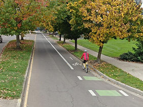
Spring 2026
This coming spring, we are planning on surveying the bike lanes in Corvallis by using aerial imagery and first hand investigations of said bike lanes. We are looking to see how safe these lanes are and visible they are to cars. This may involve collaboration with the City of Corvallis or another OSU club focused on bike safety or transportation.
This project is a work in progress and may change based on available data and member's ideas and input.
Past Projects
Fall 2024 Project:
Greening Campus: Confirming Vegetation Data with the OSU Arboretum
We helped the OSU Arboretum grow! Through validating and editing outdated GIS tree data on and around OSU's campus, we supported the Arboretum's goal to achieve level III national accreditation status.
Winter 2025 Project:
Conflict Ecology Lab: Damage mapping the genocide on the Gaza Strip in Palestine
We traced tents and other temporary structures in Gaza to provide data for a training dataset for a Segment Anything Model (SAM2) algorithm to detect displacement magnitude and movement. We utilized high-res imagery to annotate temporary settlements using QGIS. We did this to strengthen humanitarian aid delivery and understand spatial patterns of conflict-induced displacement.
Spring 2025 Project:
Mapping middle housing in Corvallis
We teamed up with The League of Women Voters to map existing middle housing in Corvallis. We accomplished this by taking trips off campus and adding data points where there was current middle housing established. This was done to provide data for the League of Women voters to use for a project they were working on to provide more affordable housing in Corvallis.
Future Projects
Possibilities are endless, and we're always eager to explore new territories.
Some areas of interest for potential future projects that have been suggested by chapter members include:
Mapping Air Filter Access
Map the distribution of adequate air filters in and around Corvallis to identify areas more vulnerable to wildfire smoke, providing crucial data for community preparedness.
Public Transportation Accessibility
Assess the accessibility and coverage of public transportation systems. Map bus stops, train stations and routes to understand how well-connected and convenient public transit options are in different areas, influencing mobility and social inclusion.
Food Deserts Analysis
Investigate areas with limited access to fresh and healthy food options. Mapping the locations of grocery stores, farmers' markets and food pantries can provide insights into food deserts, helping to address issues of food insecurity.
Tracking Wastewater Flow
Map the flow of wastewater from Oregon State University and Corvallis with the goal of revealing patterns, potential environmental impacts and key points of interest in the local wastewater system.
Do you have an idea for a future term project or project area? Please share them with us!
Mapathons
Mapathons are mapping parties, where we gather as a chapter and work together on a selected mapping project.
The idea behind a Mapathon is to get participants excited about mapping, contribute to a good cause and get used to using programs like OSM.
In the past, we held a Mapathon in collaboration with CEOAS for GIS week, where we mapped buildings, waterways and roads. The project focused on these key features in order to help organize disaster relief and hazard mitigation in remote areas.
Most projects focused on for Mapathons have a similar goal, because the information we put into the OSM database can eventually be extracted and used in real-time, in the places we are mapping.